The Brazilian Navy acts to ensure Brazil’s rights and interests in a maritime area of 5.7 million km² in the South Atlantic
By Marine Ranger (RM2-T) João Stilben – Brasília, DF
In Brazil, strong economic sectors such as agribusiness, which employ millions of people and help the country’s trade balance, are well known for their importance. But what many people don’t know is that more than 20 million Brazilians, including those who work in the countryside, have their activities directly or indirectly involved with the sea. To highlight facts like this, November 16 marks National Blue Amazon Day, established by Law No. 13.187 /15. The date corresponds to the entry into force of the United Nations Convention on the Law of the Sea, to which Brazil is a signatory.
The term Blue Amazon was coined by the Brazilian Navy in 2004 to awaken public opinion to the importance of the maritime areas under Brazilian jurisdiction, which are so vast, rich in biodiversity and natural resources, of such environmental importance and as vulnerable as the Amazon rainforest, the “Green Amazon”, whose importance was already well recognized by society.
Thus, the National Blue Amazon Day is also a representation of the efforts to develop the so-called “maritime mentality”, which consists of the degree of awareness of society and government decision-makers about the importance of activities related to the sea for the life of the nation, as well as the feeling of belonging of men and women to the Brazilian maritime community, whose synergistic interaction favors the strengthening of these activities in favor of national interests.
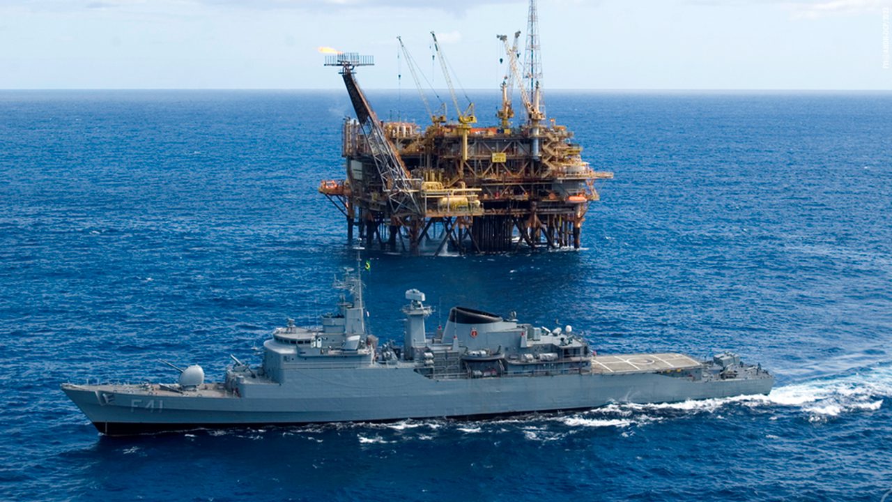
The aim is to enhance, preserve, sustainably use and protect Brazil’s Jurisdictional Waters, which cover some 5.7 million km², where more than 95% of the country’s oil is produced, 85% of its natural gas and 95% of foreign trade passes through. Where, therefore, more than 20 million jobs are sustained.
The unpublished data on the employability of the Blue Amazon was gathered by researcher Andréa Carvalho, who is a professor at the Institute of Economic, Administrative and Accounting Sciences at the Federal University of Rio Grande (RS), and one of the organizers of the book Economia Azul – Vetor para o Desenvolvimento do Brasil, published in 2022. “Why is it that when we look at a tractor we think of agriculture, wealth and exports, but when we look at a ship we don’t think about the importance of the maritime economy?” she asked.
According to her, the maritime mentality must be embedded in the lives of Brazilians, since even the agricultural inputs and machinery that enrich Brazil are dependent on transoceanic transportation to reach other countries. “We can only understand, honor and above all preserve what we know,” added the researcher.
Brazilians at sea
Today, Brazil has 81 million formal and informal employees (data from the New General Register of Employed and Unemployed and the National Household Sample Survey – CAGED), meaning that one in four employed Brazilians work in businesses related to the sea or maritime commerce.
These activities are divided into: those directly related to the sea, such as fishing, aquaculture, oil and gas, shipbuilding, maritime transportation and tourism (2.4 million employees); and those indirectly related to it, as they depend on the flow of production or the import of inputs (more than 18 million workers).
This means that the Blue Amazon is an important pillar of the Brazilian economy. The region’s contribution to the so-called “Economy of the Sea”, according to researcher Andréa, “is divided into sectors linked to the ocean, which account for 13% of Brazil’s Gross Domestic Product (GDP), and the coastal economy, which is indirectly associated with the sea, as it is developed in the municipalities adjacent to the Atlantic Ocean, accounting for 16% of GDP,” she added.
The researcher also says that if we combine all of this with activities in inland waters, we arrive at a scope that would exceed 80% of the contribution to the country’s GDP, because “we encompass everything that comes in and goes out through the ocean and basins such as the Amazon Basin, the Northeast Basin, the Paraná Basin and the East Basin, which are extremely important in terms of transporting goods and people, or communication and energy,” she said.

“GDP of the Sea”
With the aim of creating a global mindset in favor of the seas, the United Nations (UN) declared in 2017 that the period between 2021 and 2030 will be known as “the Decade of Ocean Science for Sustainable Development”.
According to the Brazilian Navy’s General Directorate of Navigation (DGN), the ocean’s current contribution to the national economy already has an added value of more than R$1.74 trillion. 45% of the fish consumed in the country is taken from the seas and, on the Brazilian continental shelf, submarine cables are installed that transmit more than 95% of internet data, interconnecting Brazil with the world. In addition, the marine subsoil has a large quantity of polymetallic nodules that can be exploited sustainably, composed mainly of manganese and iron, and other strategic elements such as cobalt, nickel, copper and calcium carbonate.
The DGN explains that there is already a Technical Group (GT) called “GDP of the Sea” underway, within the Interministerial Commission for the Resources of the Sea (CIRM), and under the coordination of the Ministry of Economy. The WG has the support of specialists from the Brazilian Institute of Geography and Statistics (IBGE), whose main goals are to identify sectors and activities that make up the Blue Economy and their contributions to the GDP of the Sea, as well as to draw up a proposal for a methodology to measure it.
For the DGN, the institutionalized measurement of the contribution of the economy related to the sea will enable a better view of the strategic relevance of the Blue Economy for the country, and will allow discussions on the sustainable exploitation of marine resources to advance. It will also help to highlight the Navy’s programs and projects that drive the defense economy and stimulate industrial and service sectors in various areas, playing the role of inducers of the Blue Economy.

Tourism and ports
Tourism is one of the three most important economic activities in the world, generating more than 300 million jobs a year. A 2017 study by the World Travel & Tourism Council ranked Brazil as the 11th largest tourism economy in the world, generating 59 billion dollars a year. Another evaluation, carried out by the Ministry of Tourism in 2017, found that of the more than 6.5 million foreigners who visited the country, almost 70% were attracted by the classic “sun and sea”.
Researchers Eduardo Sanguinet and Karina Sass estimate that, by 2030, this will be the segment with the greatest added value in the economy of coastal regions. “In Brazil, due to its immense area of coastline, the local development pattern of coastal and maritime regions depends heavily on tourism. Thus, promoting economic growth in a sustainable way is fundamental to ensuring that the ecosystems that sustain tourism opportunities are preserved and revalued in these regions,” the authors emphasized.
The Port Statistical Yearbook of the National Waterway Transport Agency (Antaq) points out that activities related to the Economy of the Sea, and linked to the ports sector, provide more than one million jobs and handled 1.2 billion tons of various products, such as soy, corn, iron ore and fertilizers. Of these, 73 million tons were handled by inland waterways.
“We have 35 public ports and 175 terminals for private use, through which 95% of all the wealth that enters and leaves our country flows. These are medicines, foodstuffs and other supplies that, at some point, were present in the hold of a ship,” said the Director of Antaq, Reserve Vice-Admiral Wilson Pereira de Lima Filho.
Admiral Lima Filho – who has already been president of the Maritime Court – also states that all charters in the country are carried out with the aim of protecting the Brazilian flag. “Not that foreign flags aren’t welcome, quite the opposite, but we want investors to come and bring resources to generate jobs and wealth for our country,” he added.

Employment and credit
Figures released by researchers Marcelo Nóbrega, Matheus de Oliveira, Sérgio Barros and Jorge Oliveira show that Brazil ranks 33rd in the world among producers of marine capture fish, with around 500 tons per year. And in an analysis carried out in 2011, marine fishing overtook continental aquaculture as the main export earner, contributing R$5 billion to GDP and generating 3.5 million direct and indirect jobs.
These figures can also be found in the book Economia Azul: vetor para o desenvolvimento do Brasil. In it, Gustavo de Moraes and Andréa Carvalho argue that the assessment of potential stocks of wealth and possibilities for extraction and energy generation, as well as sustainable activities, “is an encouragement for attracting lines of credit, public or private”.
Blue Carbon
Tarin Frota Mont’Alverne, a professor at the Federal University of CAA and PhD in International Environmental Law (Université de Paris and University of São Paulo), points out that the Blue Economy has a lot of potential to be explored not only in the areas of tourism, services and oil, but also in helping to decarbonize the country.
She says that coastal and marine ecosystems are important for combating the climate emergency, as they represent a major natural carbon sink. And the global market for so-called “Blue Carbon” is something relatively new, according to her, “which increases Brazil’s potential to improve the economic and environmental conditions of local communities”.
The researcher explains that this ‘Blue Carbon’ – the flow and storage of carbon generated biologically by marine ecosystems – present above all in Brazilian mangroves, “could mitigate climate change more significantly than the Amazon rainforest itself”. Tarin also says that resources extracted sustainably from the Blue Amazon should guarantee, in the future, not only the development of medicines, cosmetics and the production of offshore wind energy, but also the country’s own food security.
“This is the case with the potential of seaweed, which is being studied at the Federal University of Ceará. These are resources that could benefit communities living along Brazil’s coastline,” predicted Tarin.
Knowing to protect
Still on the subject of harnessing Brazil’s maritime potential, the work of the MB’s Directorate of Hydrography and Navigation (DHN) stands out. It is fundamental not only for navigational safety, through hydrographic products and services such as charts and nautical publications, which minimize risks to water transport, but also by generating crucial information for many other activities, such as: exploitation of marine resources, environmental protection and management, maritime border delimitation, marine spatial information infrastructure, sport and recreation activities, maritime defense and security, among others. Thus, society as a whole benefits directly or indirectly from hydrographic services, and this activity is strategic for the development of the Blue Economy and the application of Naval Power.
One of the most important hydrographic activities when it comes to demarcating Brazil’s control over the maritime areas granted to it by the United Nations Convention on the Law of the Sea is the Brazilian Continental Shelf Survey Plan (LEPLAC), established by Decree 98.145/89 to delimit the outer edge of this submerged extension of national territory. Through this program, Brazil applied to the UN for international recognition of the maritime area that made it possible to expand the Brazilian Jurisdictional Waters to 5.7 million km².
The delimitation activities were carried out jointly by the DHN, Petrobras and the Brazilian scientific community, under the coordination of the CIRM. The first phase of data acquisition ended in November 1996, with the participation of four Brazilian Navy ships and the collection of seismic, bathymetric, magnetometric and gravimetric profiles. During LEPLAC’s second phase, five ships were used to acquire approximately 440,000 km² of data profiles.
The information collected by LEPLAC along the entire continental margin is a public asset and, in addition to providing technical and scientific information to support proposals for the outer limit of Brazil’s continental shelf, it is made available free of charge to Brazilian researchers and students, thus contributing to the development of science in the country.
The team of professionals who work at LEPLAC – among them hydrographers, biologists, oceanographers and others – are called “bandeirantes das longitudes salgadas” (bandeirantes of the salty longitudes), as a reference to the explorers who, in past centuries, worked to expand Brazil’s territorial limits by settling the interior lands.
They are specialists from various institutions who, for more than three decades, have been working on the process of extending Brazil’s borders to the east, towards the sea. So far, more than 150 researchers have embarked on DHN ships on expeditions through the Blue Amazon, which can last up to 30 days.
On each research and data gathering expedition, the teams collect information from the seabed and the subsoil, up to a depth of more than 5,000 meters, explains First Lieutenant Lorena da Fonseca Sampaio, geologist and Deputy Advisor for LEPLAC at the DHN.
Over the years, the Oceanographic Vessels “Almirante Câmara”, “Almirante Álvaro Alberto”, “Antares”, “Cruzeiro do Sul”, the Hydrographic Vessel “Sirius” and the Hydroceanographic Research Vessel “Vital de Oliveira” have been used, as well as two civilian vessels, the MV “Discover” and the MV “Sea Surveyor”.

Present since the beginning of the program, one of the flagships of the salty longitudes is Technical Staff Captain (CMG) Izabel King Jeck, a geologist at DHN, who is also one of those responsible for defending the Brazilian agenda at the UN in New York (USA). CMG Izabel explains that the request is necessary not only because it is in the country’s interest, but also because it collaborates with an initiative by UNESCO and other international bodies to map the ocean floor by 2030.
“It’s said that we know more about the surface of Mars than our own ocean. By this we mean that the greatest depths of the sea on the planet are more than 11,000 meters and access to these regions is only possible with very complex equipment. This complexity can be compared to the challenges of studying the Moon or other planets. In addition, only 5% of the seabed has been mapped in detail, meaning that more than 95% is not really known,” said the geologist.
As well as subsidizing requests to extend the continental shelf, the data collected is also useful for expanding knowledge about the Blue Amazon. According to the Secretary of the Interministerial Commission for the Resources of the Sea, Rear Admiral Ricardo Jaques Ferreira, the process of defining the maritime area under Brazilian jurisdiction increases the opportunities for new discoveries for Brazil.
“This is a public asset, the values of which we cannot specify, because of the new information that is being validated and incorporated into the database, which so far accounts for around 900,000 km of data profiles, which is information from the seabed and the subsoil, along the Brazilian coast, towards the deep sea,” he said.

Updated map
As already reported in this News Agency, this year, as a result of the work started 34 years ago by LEPLAC, the Blue Amazon area was included in the Brazilian political map. The process of updating the Charter is the result of a study begun four years ago with the Navy, IBGE and the Ministry of Education (MEC), with the aim of changing the perception of students, professionals and society in general about the contours of Brazil’s maritime vastness.
“Since 2019, at the CIRM, we’ve been in talks with the MEC and, during this process, we’ve managed to update the National High School Textbook Plan. So, as of 2023, in geography textbooks, we are already bringing the representation of the real Brazil to school benches: Brazil Land and Brazil Sea. And since 2019, we’ve been in talks with the IBGE and, very soon, we’ll have a new Brazilian Geographic Atlas, representing this Brazil of 14.2 million km²,” said the Undersecretary of the CIRM, Captain Rodrigo Carvalho.

“All of the world’s 10 largest economies have an outlet to the sea. This great competitive and economic advantage comes largely from the coastal country’s access to the sea,” explains the Undersecretary of the Interministerial Commission for the Resources of the Sea, Captain Rodrigo de Campos Carvalho. According to him, for every 100 km² of dry territory, Brazil has 40 km² of sea; and of the federal entities, 17 are bathed by the ocean. “In addition, there are 281 municipalities facing the sea, so we are a marine or maritime country, although we talk little about it. If you add up the 8.5 million km² of land with 5.7 million km² of ocean, you get an area the size of the Antarctic continent,” he added.
“And every holder of the wealth of the sea has the burden of defending it. Hence the importance of having a strong Navy, always present and ready to defend Brazilian interests and guarantee this wealth, not just for our generation, but for future ones.”
Sea and War Captain Rodrigo Carvalho
To protect and monitor Brazilian Jurisdictional Waters, MB developed the Blue Amazon Management System (SisGAAz), one of the Force’s strategic programs. The tool integrates various pieces of equipment, sensors and systems and is connected to the networks of agencies such as the Federal Police, the Brazilian Institute for the Environment and Renewable Natural Resources (Ibama), the Federal Revenue Service and Petrobras, as well as companies capable of providing and sharing relevant information. The information obtained through SisGAAz contributes to increasing the authorities’ situational awareness of areas of interest, supporting operations resulting from Maritime Intelligence.
*** Translated by DEFCONPress FYI Team ***