Captain Tiago Prudencio Silvano
For a long time, paper maps and charts were the only way of representing geographical features, areas or phenomena located on the earth’s surface, so the production of spatial data was limited to field surveys to collect data and measure angles and distances. However, technological transformations in recent decades have brought significant advances in the field of geosciences, leading to the spread of the term Geoinfomation. Although it can be defined in different ways, according to Manual EB20-MC-10.209 – Geoinformation:
The term Geoinformation (Geoinfo) is a shortened form for the term Geographic Information. Geoinfo represents any information or data that can be spatialized, i.e. that has some kind of geographical attribute or link that allows it to be located. (EB20-MC-10.209, 1st Ed, 2014).
Some authors say that geoinformation means, first and foremost, using computers as instruments for representing spatially referenced data1, combined with the possibility of manipulating, processing and storing data. From this perspective, in a country as continental as Brazil, the incorporation of technologies in the production of geoinformation is essential for greater agility and effectiveness in the mapping process.
The production of geoinformation involves a set of technologies that enable the acquisition, storage, processing, analysis, production and representation of geographic space information. Geotechnologies include the Global Navigation Satellite System, Remote Sensing, the Geographic Information System (GIS) and Topography.
Geotechnologies have enabled the computational representation of geographical space, facilitated access to remote sensor data such as high-resolution images, as well as expanding the use of relational databases, spatial analysis functions and digital image processing tools. In addition, they have contributed to the inclusion of an increasing number of people in the GIS environment and, consequently, to the generation of large volumes of geospatial data and information.
From an application point of view, the adoption of geoinformation has a direct and indirect impact on society, whether in the daily lives of the population, with access to location-based services available on internet-connected devices and the use of navigation applications, or with the benefits promoted by the use of geoinformation in planning, management and decision-making in various economic, political and social scenarios. Thus, whenever the “where” appears among the issues and problems that need to be solved by a computerized system, there is an opportunity to consider adopting a GIS¹.
Within the Brazilian Army, geotechnologies have provided significant progress in the cartographic production process, whether in the acquisition of inputs from various sources, in the automation and optimization of processes or even in the generation of new types of products. These advances extend to the end user, with faster access to data, visualization of cartographic products in the computer environment, superposition of georeferenced layers, temporal and spatial analysis of different phenomena, among others.
The Geographic Service Directorate (DSG), the technical and regulatory support body of the Department of Science and Technology (DCT), is responsible for overseeing, planning and controlling activities related to images, geographic and meteorological information and the production of cartographic products². The Directorate is made up of its 5 (five) Directly Subordinate Military Organizations (OMDS): 1st Geoinformation Centre (Porto Alegre – RS); 2nd Geoinformation Centre (Brasília – DF); 3rd Geoinformation Centre (Olinda – PE); 4th Geoinformation Centre (Manaus – AM); and 5th Geoinformation Centre (Rio de Janeiro – RJ).
Geoinformation is the basis for producing basic and thematic cartographic products in accordance with the standards established by DSG. Today, the main cartographic products generated by the Geoinformation Centers are³:
a. Orthoimage: Georeferenced image that represents the terrain with corrected distortions. Allows direct interpretation of the terrain;
b. Digital Surface Model: Continuous representation of the terrain surface, including obstacles (trees, buildings, etc.). Enables the creation of sighting maps for troops and communications;
c. Digital Terrain Model: Continuous representation of the terrain surface, without obstacles. It is usually made from the MDS. It can be used to support engineering works;
d. Vector geospatial data: Vector representation of the terrain in the form of geometric objects such as points, lines and polygons, also known as a vector database, vector map or set of vector geospatial data. Used in information systems: C2, radar, constructive simulation (War Game) for more elaborate analysis;
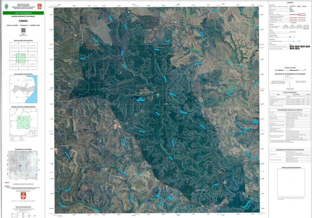
e. Orthoimage map: Cartographic document whose background is an orthoimage, with the superimposition of some planimetric and/or altimetric features. It can be used for orientation, location, measuring distances and bearings (Figure 1); and
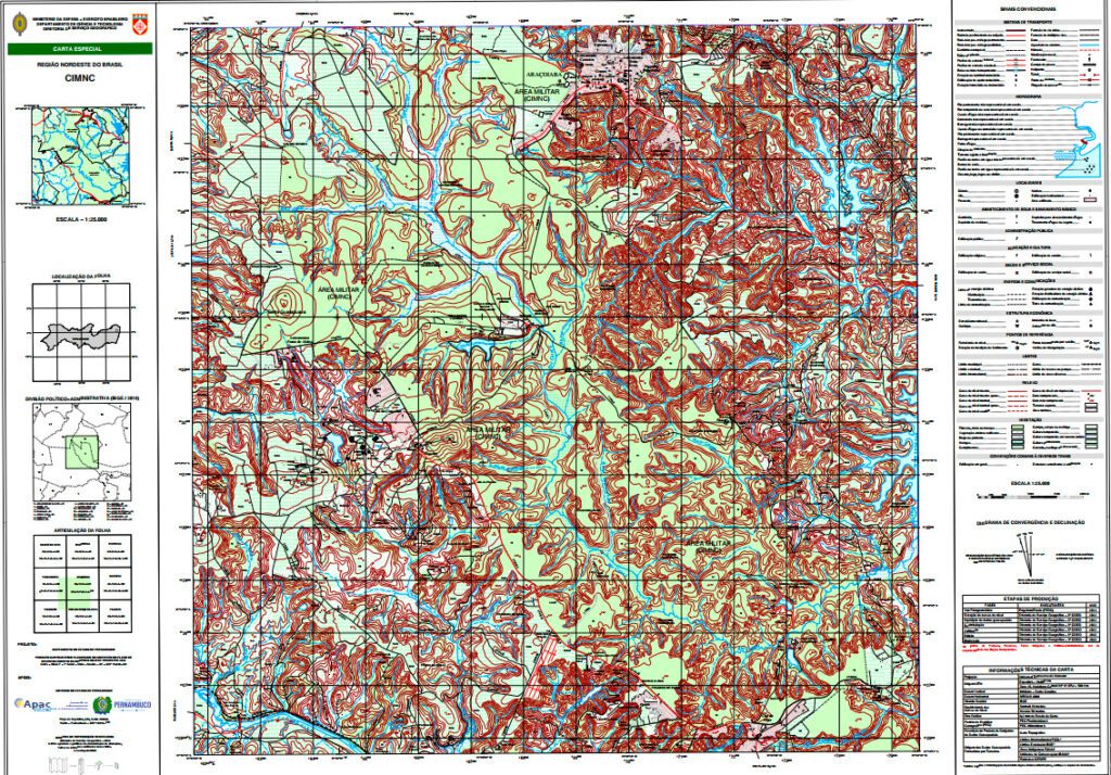
f. Topographic map: A cartographic document containing planimetric information about the terrain using symbols and conventions. It is a classic product that allows the elements of the landscape to be read clearly and quickly for orientation, location, measuring distances and bearings (Figure 2).
According to the Geoinformation Manual:
The use of geoinformation improves the decision-making process, allowing commanders to obtain more accurate data and information for planning and conducting operations, including monitoring actions and the situation in the Battlespace, in real time and with a high level of detail (EB20-MC-10.209, 1st Ed, 2014).
Finally, geotechnologies have had an impact on the way geographical space is represented, the analysis and processing of spatial data, and cartographic production methodologies. Likewise, the use of geoinformation has become indispensable for decision-making, resulting in a growing demand for geoinformation. In this sense, DSG has made efforts to disseminate and consequently use geoinformation within the Brazilian Army, making its products available through the Army Geographic Database (BDGEx) https://bdgex.eb.mil.br.
-x-
References:
- CÂMARA, G.; MONTEIRO, A. M. V. INTRODUÇÃO À CIÊNCIA DA GEOINFORMAÇÃO, INPE, 2001. Available at: https://mtc-m12.sid.inpe.br/col/sid.inpe.br/sergio/2004/04.22.07.43/doc/publicacao.pdf.
- Ordinance No. 113, of March 14, 2008, of the Commander of the Army. Available at: https://www.sgex.eb.mil.br/sg8/001_estatuto_regulamentos_regimentos/02_regulamentos/port_n_113_cmdo_eb_14mar2008.html;
- Manual EB20-MC-10.209 – Geoinformation, 1st Edition, 2014. Available at: https://bdgex.eb.mil.br/portal/media/manuais-eb/EB20-MC-10.209.pdf.
About the author:
Captain Tiago Prudencio Silvano, whose specialty is QEM Cartography, graduated from the Agulhas Negras Military Academy in 2012 and studied Cartographic Engineering at the Military Engineering Institute (IME) from 2016 to 2020. In addition, he completed his training in Military Training at the Officer Training School in 2021.
** Translated by DEFCONPress FYI Team ***